Rocket Science!
In July of 1969, Maltese viewers joined 650 million people worldwide in witnessing the first human steps on the Moon. Fast forward to 2012, and the island has progressed from observation to active participation in space exploration… and, as they say, the rest is history! If you have ever wondered what Malta has done in space, check out this timeline and find out!
FEBRUARY 2012
- Malta reaches a Cooperation Agreement with ESA.
MARCH 2013
- During the Maltese elections, the national newspaper The Times of Malta, in partnership with GeoSys, used the MAPPA platform to display the voting results in real-time. The MAPPA platform uses a Geographic Information System (GIS), which integrates sources of information including satellite data into visualisations using maps and 3D scenes.
MAY 2018
- The Malta Council for Science and Technology offers two million euros for research, development and innovation to spur the nation’s newly instituted space sector. This leads to the launch of the National Space Fund.
SEPTEMBER 2018
- The project PIXAM is launched. PIXAM uses images from the Sentinel-2 satellite to create maps to aid in a better understanding of the dynamics of the local habitat, including the mapping of selected crop patterns, habitats, and soil moisture across agricultural fields and valleys
- SAT-FIRE, a project with the main objective of improving the spatial resolution challenges of current Earth Observation Satellite systems, is launched by an interdisciplinary team of researchers at the University of Malta. More accurate predictions of marine currents by fusing data from Copernicus’ Sentinel-2 and Sentinel-3 with higher resolution data from Landsat-8 are amongst the aims of this project. Divers, swimmers, marine transport workers all stand to gain from this enhanced data set.

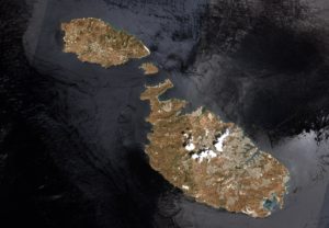
Malta as captured by the Copernicus Sentinel-2B satellite. Contains modified Copernicus Sentinel data (2017), processed by ESA, CC BY-SA 3.0 IGO. Image: © ESA. All Rights Reserved.
NOVEMBER 2018
- Astronaut Tim Peake welcomes youth and general public to an Earth Observation outreach event in Malta. Click here to see the video.
MARCH 2019
- Malta outlines vision for first National Space Strategy. This policy will incentivise start-ups and encourage small to medium businesses to access European Union funds to better utilise satellite technologies, while reducing the disparity between established entities and emerging ones such as Malta.
JULY 2019
- The 50th Anniversary of the moon landing is celebrated. In Malta, a special programme of events to commemorate this occasion is held at Esplora Interactive Science Centre.
NOVEMBER 2019
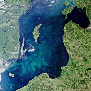
- The WaterColours project, intended to exploit satellite imagery for the estimation of ocean colour parameters in Maltese coastal areas, with special reference to harbours, embayments and the nearshore open sea areas, is launched. Measuring the colours of the ocean is important to understand the composition of ocean plankton, the amounts of pollutants and how they disperse, the health of fisheries, and to manage oil spills.
- The research project entitled Earth Observation for Historic Building Conservation and Sustainability (EO4HBCS) is launched. In a country with a Mediterranean climate like Malta, this information can lead to better management of resources such as energy and building materials, by analysing how temperatures inside homes fluctuate according to the behaviour of traditional unmodified roofs, traditional modified roofs, and modern roofs.

This Envisat image captures blue-green algae blooms filling the Baltic Sea. Detecting these tiny organisms from space requires dedicated ‘ocean colour’ sensors. Courtesy of ESA, CC BY-SA 3.0 IGO. Image: © ESA. All Rights Reserved.
JANUARY 2020
- AEROTOX, a project using Sentinel-5p datasets to predict the Saharan desert movement over the south Mediterranean region, is launched.
SEPTEMBER 2020
- The Coastal SAGE project is launched. SAGE stands for Satellite-Assisted Governance for Erosion. This project employs satellite data to map deformation, displacement and erosion on the coasts of the Maltese islands.
OCTOBER 2020
- The WARM-EO project is launched. It seeks, amongst other things, to develop a crop evapotranspiration estimation model using EO imagery for use in agriculture, and to develop an open-source water resources management platform which can be used to monitor water use at country level. This is an important step for Malta, a country with no rivers or lakes and a low amount of rainfall, resulting in an arid climate where water is a scarce and precious resource.
MARCH 2021
- The 11th ESA Training Course in Earth Observation is held. It is organized by the European Space Agency in collaboration with the Malta Council for Science and Technology.
MAY 2021
- Malta announces that a research capsule to International Space Station is to be launched later on in the year. This will be Malta’s first direct participation in a satellite launch project: Maleth. Samples of bacteria from Maltese diabetes patients will go into orbit in August.
‘Data from Earth Observation satellites are one of the most important assets brought to us by the space age. By helping us to understand our planet and secure our environment they benefit our daily lives in many ways.’ (European Space Agency)
With further funding opportunities, Malta can continue to invest in innovative research that would ultimately be of a benefit to our everyday life.

